
Anticipating the undercover: How the SkyGeo Method Helps Prevent Wellbore Failures in the Permian Basin
The Permian Basin, a cornerstone of U.S. energy production, is also home to one of the oil industry’s most pressing operational challenges: managing the risks associated with Saltwater Disposal (SWD). Injecting produced water back into the subsurface is necessary, but the consequences, if not closely monitored, can be costly and catastrophic.
Recent geyser eruptions, including high-profile events in Crane County and Toyah, Texas, underscore the urgent need for advanced early-warning systems that can detect subsurface anomalies before they become surface-level failures. This is where SkyGeo’s InSAR-based diagnostics are revolutionizing risk mitigation strategies in oil & gas.
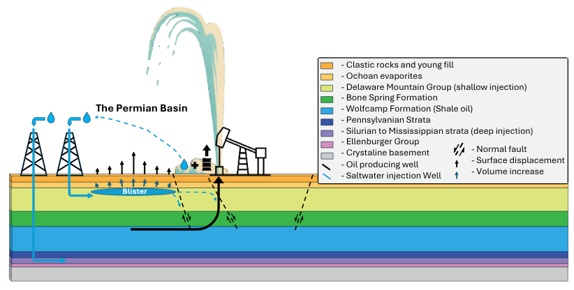
Understanding the mechanism: pressure, blisters, and failure
Saltwater disposal increases subsurface pore pressure, especially around the injection wellbores. However, this pressure can move and find weak spots like old, compromised wellbores miles away. Over time, this can lead to the formation of blisters, localized zones of rapid uplift, which are often invisible through conventional monitoring.
Our high-resolution InSAR assessment technology enables continuous surveillance of these dynamic zones. In one of the cases, surface displacements were visible up to 1.5 years before a failure occurred. This early detection window gives operators time to stabilize injection rates, reevaluate casing integrity, and avoid major incidents.
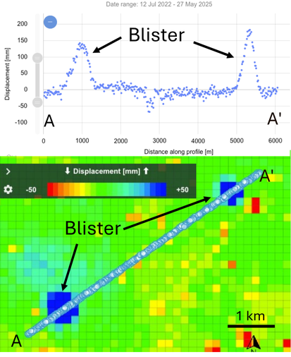
Example of blisters in InSAR data from
the Permian Basin
Case study 1: Crane County Geyser
In Crane County, persistent surface uplift was detected 1.5 years before an eventual geyser event. SkyGeo’s diagnostics revealed the progression of a pressure front, a telltale sign of pore pressure increase and moving salt water. The system’s internal pressure eventually overwhelmed a disused well, resulting in a geyser eruption. The geyser was immediately sealed, and surface uplift continued, indicating a further build-up of pressure. This pressure was eventually released through a fissure next to the well, and salt water has been leaking from this well ever since.
InSAR exploration provided a full timeline allowing for detailed interpretation:
2020–2022: Slow but visible uplift around the well.
Early 2022: Attempts at sealing and repressurization.
Late 2023–2024: Full failure with fissures and continued leakage.
Without our InSAR analysis, the warning signs would’ve been easy to miss. With it, the patterns were clear and future failures preventable.
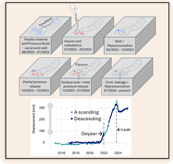
Moving surface uplift is a key diagnostic of a moving pressure front. The Crane county geyser was caused by increased pore pressure making sealing ineffective. Displacement time series and interpretation.
Case Study 2: Toyah Geyser
By contrast, the Toyah Geyser in October 2024 erupted without prior InSAR detectable deformation. This indicated a completely different failure mechanism: an internal casing collapse in the Delaware Mountain Group, not a slow building pressure anomaly.
This case demonstrates the diagnostic power of InSAR monitoring, not only to forecast events. But also in supporting effective decision-making with null-measurements. In the case of the Toyah geyser, there was no buildup of pressure, so immediate sealing is effective.
SkyGeo’s examination role in regulatory Compliance and Operational Efficiency
Subsurface injection regulations in Texas and New Mexico increasingly require data-backed justifications for SWD operations. Our InSAR intelligence supports compliance by delivering:
SkyGeo delivers these insights through a cloud-based interactive viewer, with new data coming in every 2-5 days ensuring that asset managers, geologists, and environmental officers have the most current information at their fingertips.
The Crane and Toyah geysers demonstrate two sides of the same challenge: how to detect, understand, and act on underground risk. SkyGeo’s diagnostics for wellbore integrity are proving to be essential tools, not only for predicting failures but also, for ruling out risk, enabling operators to act confidently and efficiently.
Partner with the Experts
The immense scale and complexity of managing thousands of miles of assets across the Permian requires more than just data—it requires expert geotechnical interpretation.
We invite you to discuss your unique midstream challenges and pipeline safety needs with the SkyGeo team of InSAR experts. We will show you how to implement a predictive monitoring program that safeguards your infrastructure, reduces catastrophic risk, and secures business continuity.