

Managing Risk & Productivity in the Permian Basin
SkyGeo Permian Basin Subscription Services
Introducing the first InSAR monitoring and analytics subscription service designed specifically for managing risk for oil and gas operations in the Permian Basin.
-

Permian Basin-Wide Subscription Service
Need to characterize and understand subsurface issues with wide-area implications like induced seismicity? We now re-process InSAR over the whole Permian Basin monthly.
-

Local Permian Basin Subscription Service
Do you have direct responsibility for the safety of operations and need to understand the ground stability local to your assets? We process locally on-demand as frequent as your oilfield operations need it.
-

‘Insights’ Subscription Service
Translating a tsunami of InSAR data correctly to subsurface signal by people with industry knowledge and experience. It is always easy to identify problems after they occur but forecasting is hard.
Fluid Migration in the Subsurface
It is commonly accepted that the increasing seismic activity in the Permian is induced by oilfield activity, notably with increasing salt water disposal. Pore pressure is going up as a result of different factors acting together in the busy subsurface. But exactly how and where this causes seismicity is not fully clear yet.
The migration of fluid in the subsurface will leave a footprint on the surface, which is subtle or invisible to the naked eye, but can be detected in InSAR. Correlation between injection volumes, surface heave and seismic events is indirect at best. This makes modeling and forecasting still difficult.
In the meantime, the regulator has been limiting injection in the Seismic Response Areas (SRAs) so the stakes are high to get the pore pressure variations better under control. Careful characterization, dynamic mapping and modeling are now an essential part of industry’s collaborative efforts to understand the dynamics.
Monitoring for Oilfield Operations
There are several types of monitoring for these operations problems now. There is local wellbore data – and volumetric production and injection data – the latter available basin-wide. Wide area seismic monitoring with TexNet is a lagging indicator for problems; microseismic over these very large areas. Into this mix we now bring operational InSAR with high revisit frequency.
We have shown the use of InSAR as an innovative 4D-like technique by inversion of the surface results elsewhere, for example cases involving induced seismic issues and for conventional and unconventional production monitoring.
For the Delaware Basin, several academic studies have shown basin-wide D-InSAR data; typically, the picture that emerges is distributed subsidence and heave which has been accelerating over the last 8 years; and there is a link with regional faulting. For the Midland Basin, the surface data are not available yet.
With the advent of high-performance compute and with the availability of worldwide satellite SAR imagery, we are now able to produce high quality InSAR results continuously in near real-time.
Our earlier experience with InSAR for induced seismicity, for example in the giant gasfield of Groningen showed that the cause and effect relationship is highly complex and that the earlier operators can get access to data, the faster they can build insight and the better they can respond.
Wide area InSAR processing service
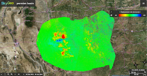
We now routinely do InSAR processing over the whole Permian Basin and we offer access to these wide area data as a subscription service. This covers the Delaware Basin, the Midland Basin and the Central Basin Platform.
The InSAR data shows that the surface of the Basin is in continuous up and down motion at the millimeter scale and in many parts of the area. This is an essential additional tool for building up knowledge of slow subsurface migration patterns. You can subscribe to these surface data as we make them available every month.
Computing these surface motions is just the first step. We assess the wide area InSAR subsidence and heave data for significant signal relating to the sub-surface. This does involve spatial and/or temporal smoothing.
With InSAR, we can dissect the complex patterns associated with the evolution seismic events so we can do history matching and build up insights in support of forecasting.
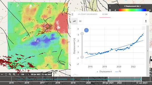
Translating InSAR Locally: Surface Signal to Subsurface Model
The effects at the surface as a result of net fluid withdrawal and injection for individual producing wells typically manifest locally. By doing these forensics at scale, we can support careful evaluation of injection strategies in near real time.
So how do we set up a local InSAR monitoring strategy for individual wells or clusters of injection wells when the subsurface is so busy – and when the surface is moving everywhere all the time? At the surface, we see the compound effect of production and injection in a dozen stacked reservoirs and SWD both above and below them.
We do local InSAR time series processing that is different from the wide area processing, in terms of context ingestion and in terms of resolution in time and space.
The important and difficult step now is finding relevant signal in this very large area where the surface is in continuous motion on the millimeter scale. There is a lot of geomechanically irrelevant signal in the compound InSAR surface motion signal – in other words geomechanical noise. We need to remove this noise to see the part of the motion that is driven by the deeper subsurface.
After optimized local processing, we do careful verification and validation using available external data. Then we assess patterns in context of what is known locally: lithology, structure, wellbore placement, injection and production balance over time, etc. The next step is visualization of the uplift and subsidence patterns, and assessing if they are atypical given the conditions.
This needs to be assessed separately from the wide area data or you will miss them. For these local events, the InSAR processing needs to be done separately and validated specifically. Also, the signal likely contains too much noise. It needs to be evaluated separately for it to be used effectively.
The Key to a Successful InSAR Monitoring Strategy.
So how do we set up an InSAR monitoring strategy for individual injection wells or clusters of injection wells when the sub-surface is so busy? We see the compound effect at the surface of production and injection in a dozen stacked reservoirs and SWD both above and below them?
The important and difficult step now is finding relevant signal in this very large area where the surface is in continuous motion on the millimeter scale. There is a lot of geomechanically irrelevant signal in the surface motion – in other words InSAR noise. We need to remove this noise to truly see the part of the motion that is caused by the deeper sub-surface.
We start with one of the harder jobs: careful verification and validation in context of what is known locally.
The key step is: can we identify and isolate typical patterns uplift and subsidence? The migration of fluids effects in the subsurface will leave a footprint on the surface, which is subtle or invisible to the untrained eye. This needs to be assessed separately from the wide area data or you will miss them.
For these local events, the InSAR processing needs to be done separately and validated specifically. Also, the signal likely contains too much noise. It needs to be evaluated separately for it to be used effectively.
Is InSAR monitoring right for your oilfield operations?
InSAR has changed a lot in recent years. It’s now available faster and at higher resolutions, which is a good thing. But when everything is moving, this tsunami of data brings new challenges. So we help you address these challenges by doing the essential work of mapping the actual surface dynamics.
After verification and validation, we need to filter and scrub the data, and put it in context. The InSAR service is a readily available diagnostic tool that is complementary to your sub-surface and downhole measurements. In order to make sense of this very large data set, we do a templated discovery of what it means: for example supporting inversion of the surface data for your geomechanical model or history matching with oilfield production and injection data.
As we progress through this shared discovery, in every case we have worked on, we have added value in terms of area reservoir management. The positive ROI for the operator will continue to grow as we learn how to read the data better.
Contact SkyGeo
Have a question about what you’re seeing in the map or whether you need higher-grade monitoring? Share a few details about your assets and objectives and a SkyGeo specialist will get back to you with the best next step.