
SkyGeo recently presented at an energy industry conference in Dallas on ‘Induced Seismicity’ (earth movement caused by human activity). Here are my four key takeaways on this critical issue for the energy industry, after listening to the top experts in the field.
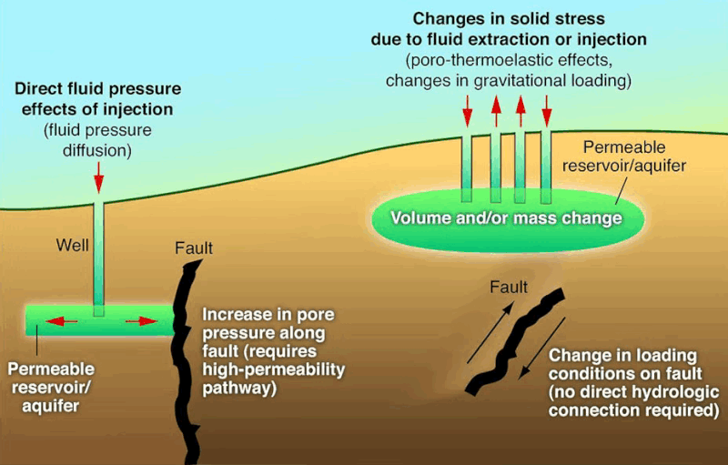
1. Induced seismicity is a wide area problem. When large amounts of fluids are injected in the ground, there is an unpredictable ripple effect that is wildly non-linear and can impact areas 10 – 20 miles away. Standard modeling is ineffective in understanding where the earth will move next and how serious it will be.
2. Collaboration between neighboring operators is essential and underway. Energy companies are taking the increased seismic activity seriously and are beginning to have their teams of geoscientists work together to manage a complex subsurface problem over a very wide area.
3. “InSAR is not just useful, it is essential for understanding induced seismicity.” – That’s a quote from Professor Peter Hennings of the Center for Injection and Seismicity Research at The University of Texas at Austin. The CISR has led the way in applying the initial version of InSAR to the salt water disposal problems in the Permian Basin and recognizing its importance – and are persuading others to take this remote sensing technology serious as a 4D tool.
4. “We need more data” — According to attendees, they need more data to better understand and manage their reservoirs locally and on the basin-wide scale. Sophisticated InSAR analysis is a key method in attaining that data.
It was good to see the positive response from attendees regarding SkyGeo’s 4D analysis of the Permian Basin that was featured in the The Wall Street Journal. While SAR images are now widely available, doing INSAR correctly at this scale is still difficult.
The real work is now the translation to more local and more dynamic 4D information similar to our data in the The Wall Street Journal. This means truly understanding InSAR in a 4D way to track the “ripple effect” of induced seismicity and mitigate its risks.
Partner with the Experts
The RRC's new guidelines are a call for specialized geotechnical and data analysis expertise. Don't face these compliance challenges alone.
-
Injected fluids and pressure changes do not necessarily remain close to the well where they originated. Pressure can migrate through connected formations and faults, so the response may appear many miles away and may involve multiple operators and stacked subsurface systems. That is why a basin or regional view is important before interpreting a local earthquake or deformation pattern.
-
Seismic networks tell you where and when earthquakes occur. InSAR adds a different measurement: the slower spatial pattern of surface uplift and subsidence that can develop as pressure and fluids change below ground. Looking at both helps teams compare seismic events with longer-term ground behaviour rather than treating earthquakes as the only observable response.
-
It can provide evidence of how a pressure-related response evolves across space and time, but the surface pattern is indirect. The useful workflow is to compare deformation with injection, production, faults, geology and seismicity, then test whether the observations support a coherent interpretation. The Tubbs Corner case illustrates why the source of an anomaly may be some distance from its surface expression.
-
The subsurface does not follow lease lines. When pressure and fluid migration operate across a wide area, one operator's data may explain only part of the system. A common regional ground-motion baseline can give neighbouring teams a shared surface view, which becomes more useful when combined with injection, production, seismic and geological information from across the affected area.
-
InSAR can improve understanding of how the ground and subsurface system have evolved, but it should not be presented as a deterministic earthquake-prediction tool. Its strength is adding spatial and temporal evidence to history matching, model testing and risk screening. Forecasting remains uncertain, so decisions should combine multiple datasets and explicit risk thresholds.
-
Use it first to identify regional deformation patterns and changes through time, then focus local analysis on areas where movement, seismicity and operational exposure overlap. The next step is to integrate the surface data with injection, production and geomechanical context. That moves the workflow from simply seeing movement to testing what it may mean for operations.
We invite you to discuss your unique Permian Basin challenges and monitoring needs with the SkyGeo team of InSAR experts. We will show you how to transform raw satellite data into the actionable intelligence required to maintain compliance, ensure safety, and secure the future of your assets.
